• If You Are Having Trouble Logging In with Your Old Username and Password, Please use this Forgot Your Password link to get re-established.
  • Hey! Be sure to login or register!

On-Line Weather Tools, What Do You Use?

Steve, don't forget that none of this stuff actually counts for legality purposes even though every site mentioned is better than basic DUATs. To cover myself I always download a complete route briefing via the DUATs app on my smart phone so I can prove (via my N#) that I actually did get a briefing. Looking at it is optional since I've already gathered all of the info via other sites, even TFRs.
 
Steve, don't forget that none of this stuff actually counts for legality purposes even though every site mentioned is better than basic DUATs. To cover myself I always download a complete route briefing via the DUATs app on my smart phone so I can prove (via my N#) that I actually did get a briefing. Looking at it is optional since I've already gathered all of the info via other sites, even TFRs.
I believe Four Flight's downloaded brief fully qualifies...
 
I carry a blue card with a hole in it. When I hold the card up to the sky, looking through the hole, if the colors match I'm is good to go.
 
So you don't have to have a tradeaplane subscription to get free weathertap? It was prompting me for a login...

sj
 
I just went to the play store and downloaded it, free. Maybe things have changed
 
I don't have a WeatherTap login, which my "free" version prompted me for.
 
Lockheed Martin Flight Services web site is the FSS's site for briefs and filing flight plans. Also covers the "legal" part of a brief.
www.1800wxbrief.com

You can open and close plans with a text msg. Pretty cool in areas where no radio coverage, or when the one briefer is busy on multiple freq's, and you are trying to close before going NORDO. One can save flight plans, all info is there for next time, kind of like your own personal Master Flight plan. Makes filing much faster.

I think their graphics are ok. I like a combo of NOAA's metar maps http://www.wrh.noaa.gov/zoa/mwmap3.php?map=usa
NWS local and aviation stuff.
The Wind Map is neat http://hint.fm/wind/ while its not an app.

Cell phone apps include MyRadar Pro. AeroWeather. and Mike's web cam viewer AKAvCAMsLt.

The AeroWeather app, one can customize different "groups". such as specific cross country routes. While in cell coverage you can update along the way, can be set to display in Raw or Decoded,

( VfrNotRecommendedWeAppreicaiatePilotreportscontactflightwatchononetwentytwopointzeroforfurtherinformation)
 
I found this today on a FB post from Back Country Flyers

https://www.windyty.com/
At first glance it just looks cool but if you dig into it you can actually get some good weather.

......Mike

I like that you can get a winds aloft guess for a week out
 
Steve, don't forget that none of this stuff actually counts for legality purposes even though every site mentioned is better than basic DUATs. To cover myself I always download a complete route briefing via the DUATs app on my smart phone so I can prove (via my N#) that I actually did get a briefing. Looking at it is optional since I've already gathered all of the info via other sites, even TFRs.

EDIT: In retrospect, I wasn't completely accurate. Much if not all weather info comes from government sources or contractors. I would think the weather info on non-government sites actually is legal, but not all sites maintain a log of your activity. What I should've emphasized was you may need to be able to prove that you did your preflight weather homework. Sorry.

It is such a good exercise for someone to ask this question every now and then so we can see all the great new tools out there---thanks SJ!
 
Last edited:
Thread ressurection.

Anyone else use the Aeroweather app? It’s my favorite current conditions weather source. Have you noticed the new version has runway/waterlane diagrams that show runway heading wind and crosswind components? Very interesting. Not that I couldn’t figure it out if I wanted to, but I haven’t done so since I was a student pilot.
 
Another vote for Weathermeister. I've tried dozens of sites, and often visit several, but my "go-to" site is Weathermeister. Been using it for years, and I find it to be very complete and easy to digest. I think it's the best out there.
 
Thread ressurection.

Anyone else use the Aeroweather app? It’s my favorite current conditions weather source. Have you noticed the new version has runway/waterlane diagrams that show runway heading wind and crosswind components? Very interesting. Not that I couldn’t figure it out if I wanted to, but I haven’t done so since I was a student pilot.

That and MY Radar app on the Iphone phone, also use intellicast radar summary a lot.
 
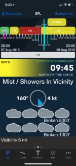
For super fast info I like the StationWX app on a phone. Provides a very easy to see visual display of conditions.
For more in-depth then these others posted above are great.

IMG_2130.JPG

IMG_2128.JPG

IMG_2129.JPG

IMG_2131.JPG

IMG_2132.JPG


Sent from my imitation glass cockpit using SuperCub.Org mobile app
 

Attachments

  • IMG_2130.JPG
    IMG_2130.JPG
    177 KB · Views: 125
  • IMG_2128.JPG
    IMG_2128.JPG
    173.5 KB · Views: 119
  • IMG_2129.JPG
    IMG_2129.JPG
    139.2 KB · Views: 125
  • IMG_2131.JPG
    IMG_2131.JPG
    131.7 KB · Views: 145
  • IMG_2132.JPG
    IMG_2132.JPG
    145.1 KB · Views: 125
Regions seem to have better weather from different sources.

We found that WindyTV and weather underground was very good in Sitka, however, we had about seven sights we would look at including the radar and sat. pictures.

We have cameras, bouys, and various other sources, yet we still have to use good judgement when we get out in the air. Sometimes the sats and radar will tell you the wrong thing!
 
Back
Top